.png "tenexe")

Map Reading Charts Large
This product is not available in the selected currency.
In Stock
Backordered
Out of Stock
Description
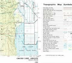
- Detailed Representation: Offers detailed maps with terrain features, landmarks, and topography.
- Navigation Aids: Includes compass roses, grid lines, and elevation contours for orientation.
- Map Symbols: Features symbols for roads, water bodies, vegetation, and man-made structures.
- Route Planning Tools: Provides scales, protractors, and plotting tools for route planning.
- Emergency Preparedness: Includes escape routes, shelters, hazards, and rescue locations for safety.
- Training and Education: Used for navigation training, wilderness survival, and outdoor recreation.
- Durability and Portability: Printed on durable, waterproof material for outdoor use.
- Educational and Recreational Use: Suited for outdoor enthusiasts, military personnel, educators, and students.
- Visual Learning Tool: Enhances map reading skills through visual learning experiences.
- Versatile Application: Beneficial for recreational, educational, and professional purposes.
Opps
Sorry, it looks like some products are not available in selected quantity.